The Baltimore Regional Transportation Board (BRTB), as the metropolitan planning organization for the Baltimore region, seeks public comments through Friday, July 17 on a new section of the Patapsco Regional Greenway in Howard and Baltimore Counties.
In 2017, the BRTB approved a concept plan for the Patapsco Regional Greenway. Now they are seeking your input on the Elkridge to Guiness route.
Details about the comment period and how to provide comments are available below.
About the Patapsco Regional Greenway
The Patapsco Regional Greenway maps the main alignment of a 40-mile, shared-use trail running through the Patapsco Valley from Baltimore’s Inner Harbor to Sykesville in Carroll County. The trail, if completed, would pass through or near the communities of Cherry Hill, Baltimore Highlands, Halethorpe, Elkridge, Catonsville, Ellicott City, Oella, Daniels, Woodstock, Marriottsville, and Sykesville.
About the Elkridge to Guinness Project
This project will provide preliminary design drawings for a 1.2 to 2.5 mile segment of the Patapsco Regional Greenway connecting Patapsco Valley State Park, Main Street in Elkridge, and the Guinness Open Gate Brewery.
The goals of this project are to:
- build a low-traffic bicycle and pedestrian facility
- improve access to the nearby natural environment
- create a new gateway to downtown Elkridge to support economic development
Choosing the Best Pathway
Earlier this year, the design team studied the area and developed three options, also called “alignment alternatives,” for the Elkridge to Guinness connection and the Patapsco River crossing.
Each of the three potential trail placements include a Patapsco River crossing. All alternatives would also pass through the numerous wetlands and floodplains of the Patapsco River Valley. Federal and State regulations provide protections for the river and its associated wetlands and floodplains, so the design team looked for options that would minimize impacts to these environmental resources.
The BRTB seeks feedback on three possible trail routes. Highlights are below.
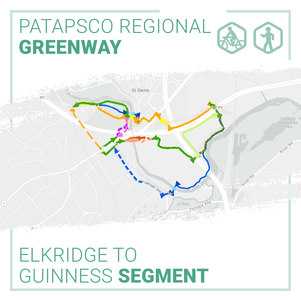
- Alternative 1: The Patapsco Route – The Patapsco Route has several options to take trail users through the floodplain of the Patapsco River and into Historic Elkridge via a bridge over the Patapsco River. Changing Main Street in Elkridge to a one-way road would provide enough space for a low-stress separated bike lane. Length: 1.8 Miles; Cost Range: $2.5 to $4.2 Million.
- Alternative 2: The Northern Link – The Northern Link efficiently ties the area of Guinness Open Gate Brewery to the Thomas Viaduct inside the Patapsco Valley State Park. Sharrows, also known as shared lane markings, along the low-volume Levering Avenue would allow trail users to come into Historic Elkridge. Length: 1.2 Miles; Cost Range: $1.9 to $2.4 Million
- Alternative 3: The Elkridge Spur – The Elkridge Spur provides efficient connections between the Guinness Open Gate Brewery, Historic Elkridge and the Park, with an optional loop trail that would also provide an opportunity to enjoy the serenity of the Patapsco River. Length: 2.5 Miles; Cost Range: $3.8 to $4.3 Million
Based on your input, and the input of our project partners, the project team will choose a preferred alignment and complete a preliminary design. Once 30% design is completed, Howard and Baltimore Counties will apply for a grant from the Maryland Department of Transportation (MDOT) to complete the design.
View the alignment options in our StoryMap | Listen to an overview about the project
Share Your Thoughts
The public is invited to share their feedback on the three design alternatives from Monday, July 6 through Friday, July 17, 2020.
There are four ways you can comment:
- View the StoryMap and take our survey @ https://www.surveymonkey.com/
r/98F8M6Q - Email your thoughts to comments@baltometro.org
- Call us at 410-732-0500 x 1042 and leave a voicemail with your feedback
- Share your thoughts via Twitter at @BaltoMetroCo | @BmoreInvolved | #BRTBlistens
For more information:
Contact Sheila Mahoney, senior transportation planner, by email at smahoney@baltometro.org, or by phone at 410-732-0500 x 1042.
Notice
The Baltimore Regional Transportation Board operates its programs and services without regard to race, color, or national origin in accordance with Title VI of the Civil Rights Act of 1964, and other applicable laws. Appropriate services can be provided to qualified individuals with disabilities or those in need of language assistance who submit a request at least seven days prior to a meeting. Call 410-732-0500.