About the Patapsco Regional Greenway
The Patapsco Regional Greenway (PRG) Plan envisions a 40-mile, shared-use trail running through the Patapsco Valley from Baltimore’s Inner Harbor to Sykesville in Carroll County. This trail would improve access to important regional amenities such as the MTA’s Light RailLink, the Inner Harbor, and Patapsco Valley State Park, and also connect to important regional bicycle and pedestrian trails such as the Middle Branch Trail and the BWI Trail, while passing through or near the communities of Cherry Hill, Baltimore Highlands, Halethorpe, Elkridge, Catonsville, Ellicott City, Oella, Daniels, Woodstock, Marriottsville, and Sykesville.
Parts of the 10-12 foot wide shared-use trail are already constructed and open for use:
- Freedom Park Trail (Carroll County, 1.6 miles)
- Grist Mill Trail (Baltimore County, 5.2 miles)
- Gwynns Falls Trail at the Middle Branch (Baltimore City, 1.6 miles)
- Gwynns Falls Trail at Ridgely’s Cove (Baltimore City, 1 mile)
- Jones Falls Trail at the Inner Harbor (Baltimore City, 0.4 miles)
- Waterfront Promenade (Baltimore City, 1.3 miles)
- Port Covington Waterfront Parks (Baltimore City, 1.2 miles)
Remaining portions will be designed and constructed based on local priorities and funding availability.
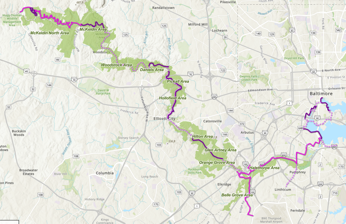
A map of the Patapsco Regional Greenway can be viewed here.
The Baltimore Regional Transportation Board (BRTB) with BMC and consultant support have led 30% design of PRG segments in partnership with member jurisdictions.
Guinness to Southwest Area Park Project
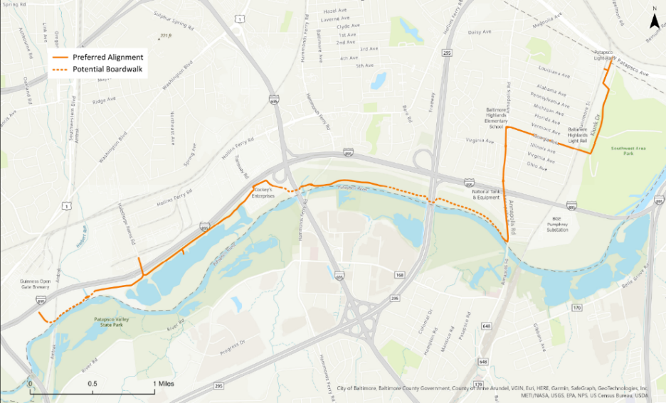
The Guinness to Southwest Area Park segment of the PRG extends approximately 5.5 miles from the Guinness Open Gate Brewery to the Southwest Area Park and the MDOT MTA Patapsco Light Rail Station in Baltimore County. The segment will consist of a 10-12 foot wide trail extending east from the Guinness Open Gate Brewery beneath the MARC train bridge, then travel parallel to scenic bodies of water before traveling under the I-695 overpass. The trail would then run along the Patapsco River along an elevated boardwalk, crossing Hammonds Ferry Road and then continuing under the I-895 overpass along the way. The trail would turn north running parallel to Annapolis Road as a shared-use path with a 5-foot grass buffer before turning east onto Georgia Road as a bicycle boulevard. The trail would then extend onto Klunk Drive to continue north through Southwest Area Park. This end of the segment would connect to the MDOT MTA Patapsco Light Rail Station and Patapsco Avenue.
In spring 2023, four trail alternatives were presented for public input. After reviewing public comments, conducting thorough field investigations, and taking into account environmental considerations, one alignment was selected. The selected alignment was chosen due to reduced wetland impacts, lower estimated construction and maintenance costs, reduced amount of roadway crossings, and views of the Patapsco River and surrounding woodlands. A second public input period was held in fall 2023 and will be followed by the development of 30% design documents for the segment which is anticipated to be completed in early 2024.
Elkridge to Guinness Project
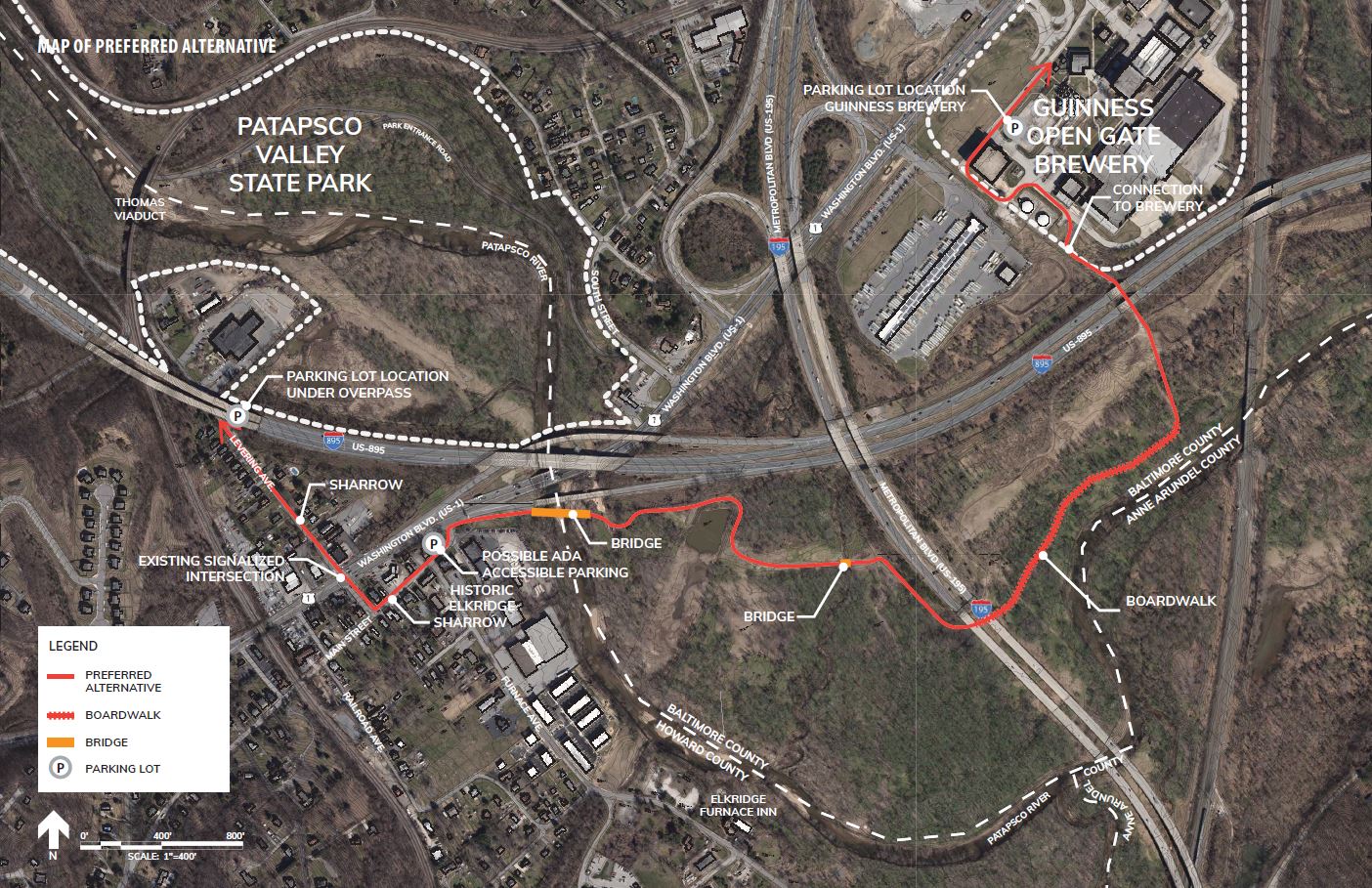
The Elkridge to Guinness segment of the PRG extends approximately 1.5 miles from Historic Elkridge to the Guinness Open Gate Brewery. The segment will consist of a 10-12 foot hard surface trail extending west from the Guinness Open Gate Brewery, paralleling the Patapsco River along an elevated boardwalk, providing stunning views of the forested floodplain and wetlands.
The trail would continue under I-195 before crossing the Patapsco River via a 300+ foot scenic bicycle/pedestrian bridge which would ultimately bring visitors into Historic Elkridge.
In 2020, three trail alternatives were presented for public input. Based on public input, field investigations, and environmental considerations, the project team selected an alignment and developed 30% design documents. The selected alignment will provide a practical, constructible and impactful investment, new pedestrian and bicycle access connecting Howard and Baltimore Counties via a scenic bridge crossing over the Patapsco River, while also leveraging Howard County’s existing investments in the transportation network and the general comfort levels of Main Street and Levering Avenue for biking and walking.
Sykesville to McKeldin Area Project
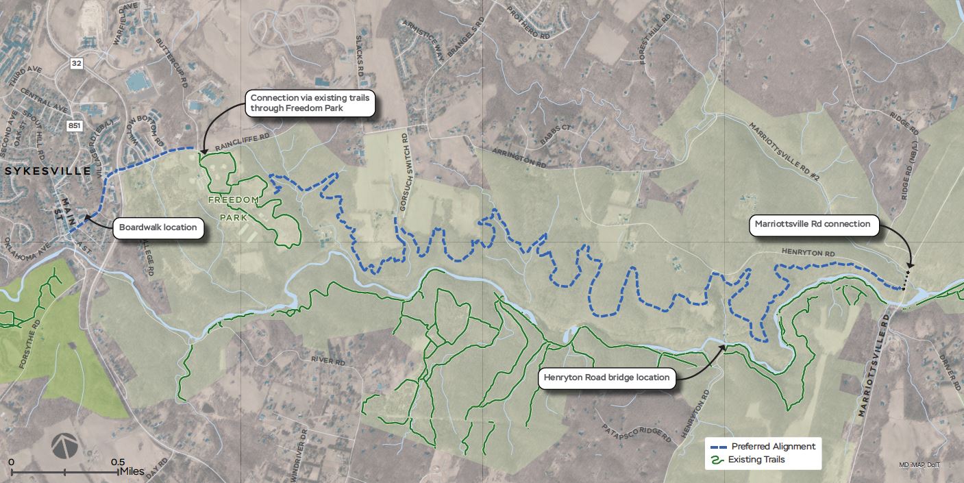
The Sykesville to McKeldin segment of the PRG extends approximately 7.9 miles and consists of two sections - 1) the western portion from downtown Sykesville to Freedom Park and 2) the eastern portion from Freedom Park to the McKeldin area of the Patapsco Valley State Park. Section one will consist primarily of a 10-12 foot shared-use path, on-road facilities, and a boardwalk structure and would travel from Main Street in downtown Sykesville, north along Sandosky Road, crossing MD 32 to Raincliffe Road, and finally to Freedom Park via the Buttercup Road intersection for a total of 0.38 miles. Section two will be a natural surface trail beginning in Freedom Park and meandering through Patapsco Valley State Park towards the Heart of Maryland Bowhunters Club property. From there, the trail would veer south towards the South Branch of the Patapsco River, crossing over the historic Henryton rail tunnel, through the historic Henryton Sanatorium, paralleling Henryton Road and finally crossing Marriottsville Road before ending in the McKeldin area of the Patapsco Valley State Park for a total of 7.5 miles.
In June 2021, two alternative alignments for each section were presented for public input. After reviewing public comments, considering information from extensive field visits, and environmental considerations, a selected alignment for each section was chosen. A second public input period was held in fall 2021 followed by the development of 30% design documents in 2022.
Stoney Run Trail Project
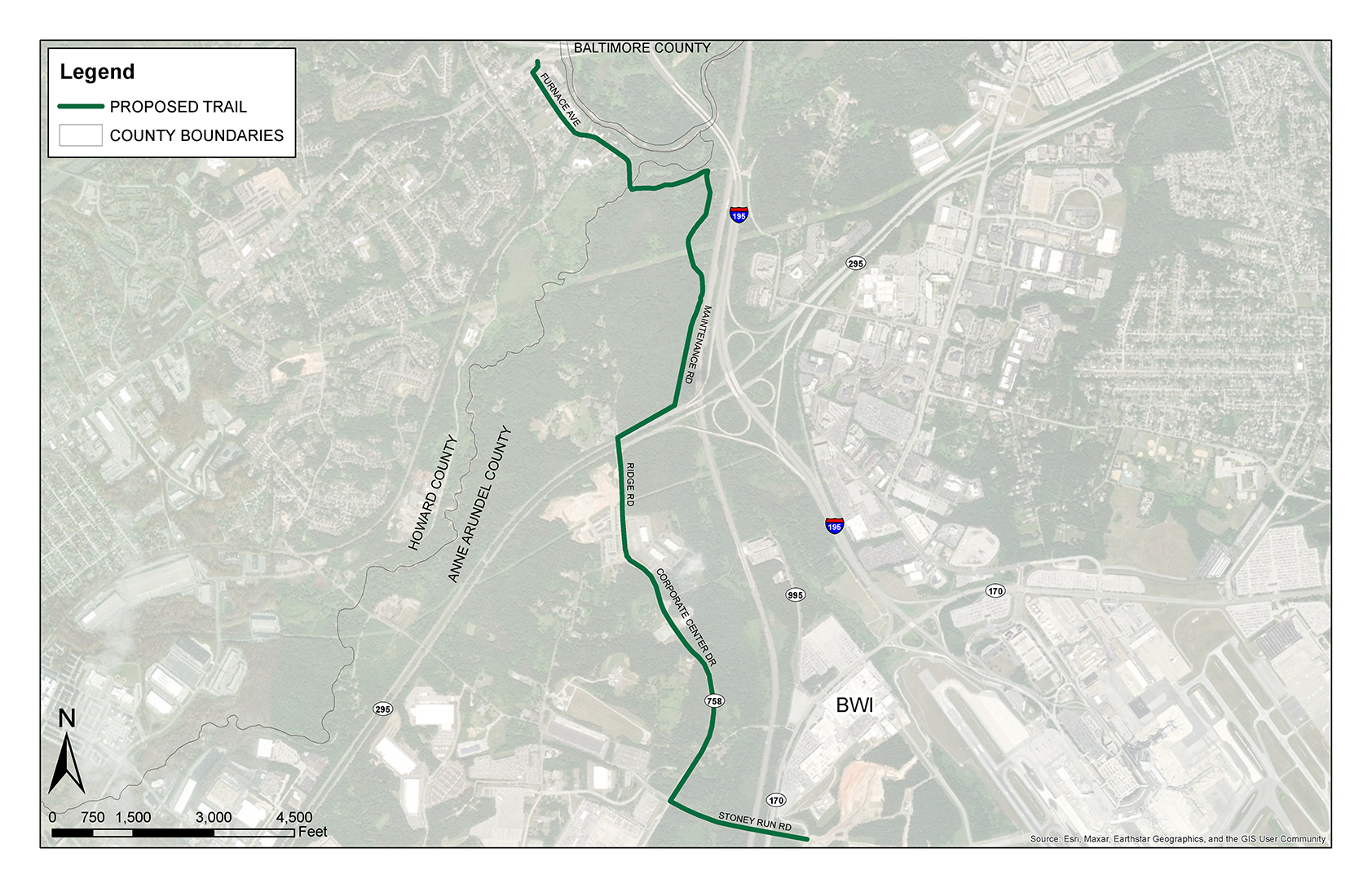
The proposed Stoney Run Trail segment of the PRG extends approximately 4-miles from Historic Elkridge to the BWI Trail. In December 2023, the 30% design project kicked off. The project team will explore the concept level alignment proposed in the PRG Plan and develop alternative alignments. These alignments will be presented for public feedback. Public input along with field investigations, environmental considerations and other elements will inform the selection of one alignment for further study and the development of 30% design documents.
The concept level alignment of the trail begins at Main Street in Historic Elkridge and the PRG: Elkridge to Guinness segment and extends south along Furnace Avenue. The trail would continue east along Furnace Avenue at Ridge Road, then turn south onto an existing unpaved maintenance road. The trail would then leave the maintenance road and bear southwest, climbing uphill towards the Ridge Road Bridge over MD 295. After crossing over MD 295, the segment would continue south along Ridge Road onto MD 758 before turning east onto Stoney Run Road to connect with the existing BWI Trail.
Patapsco Regional Greenway: Operations and Maintenance Guidelines and Branding Plan
BMC is working with member jurisdictions and the Maryland Park Service to:
- Develop an operations and maintenance plan with standards for short, mid and long-term activities for the PRG. The standards will be based on facility type (asphalt, boardwalk, on-road, etc.) and take into account the existing policies of the jurisdiction or agency responsible for maintenance and operations of a given trail segment.
- Identify the jurisdictions and agencies responsible for maintenance and operations of each existing and planned segment of the PRG.
- Engage a steering committee to support development of a branding plan for the PRG. Identify existing branding if any. Design branding for signage, trail markings, educational and interpretive displays, a PRG web based map and website and a printable map.
- Identify potential funding opportunities such as sponsorships for educational and interpretive displays.