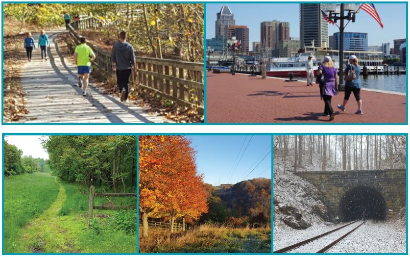
Active transportation is critical to the Baltimore region’s transportation system and includes bicycling, walking, electric scooters and electric bicycles, and using a wheelchair. Almost all trips begin or end with some form of active transportation, including trips made using motor vehicles or transit. Most of us use active transportation on a weekly if not daily basis.
A connected and safe active transportation network benefits the entire region by improving access to destinations that meet the daily needs of people of all ages and abilities. Broadening transportation choices and potentially increasing active transportation use can:
- Help people reach job opportunities more easily
- Reduce air pollution and emissions from cars
- Help people stay active
- Provide tourism opportunities
- Boost the economy in the area
The Bicycle and Pedestrian Advisory Group (BPAG) is a Baltimore Regional Transportation Board (BRTB) subcommittee made up of representatives from the seven jurisdictions in the Baltimore region and representatives from Maryland Departments of the Environment, Planning and Transportation. BPAG meetings serve as a place to share information and ideas for improving active transportation in the region. Important regional initiatives such as the annual regional bicycle facility inventory and top regional active transportation priorities emerged from BPAG. The subcommittee also advises the Technical Committee and BRTB on active transportation issues.
Top Regional Active Transportation Priorities
The list of top regional active transportation priorities was developed in collaboration with over 20 representatives from each jurisdiction in the region and MDOT. The priorities included in the list are grounded in adopted bicycle, pedestrian, Complete Streets, and park and recreation plans. The top priorities informed Resilience 2050, can assist in cross jurisdictional collaboration and inform efforts to develop a vision for an integrated regional bicycle network. The top active transportation priorities include at least one priority in each jurisdiction in the Baltimore region, with many being cross-jurisdictional. The priorities are illustrated in this map.
Bikeable Baltimore Region
BMC is collaborating with local jurisdiction, the state, and other stakeholders on the Bikeable Baltimore Region (BBR) project, which will identify a bike network of existing and planned bike facilities that is safe and comfortable for people of all ages and abilities. This regional bike network will benefit everyone by connecting our local communities and providing safe and equitable access to places people need to go like public transit, schools, work, and parks. Identifying a comfortable, continuous, and safe bike network made of prioritized bike facilities will ensure that funds are used where they will have the greatest impact and help cities and counties pursue federal and state funding to design and build the network more quickly.
Patapsco Regional Greenway
The Patapsco Regional Greenway (PRG) Plan envisions a 40-mile, shared-use trail running through the Patapsco Valley from the Baltimore Inner Harbor to Sykesville in Carroll County. This trail, once completed, will weave together existing trails and connect communities from downtown Baltimore City all the way to Sykesville, providing for transportation and recreational activities while preserving the natural beauty of the Patapsco Valley. Click here for more information about the Patapsco Regional Greenway.
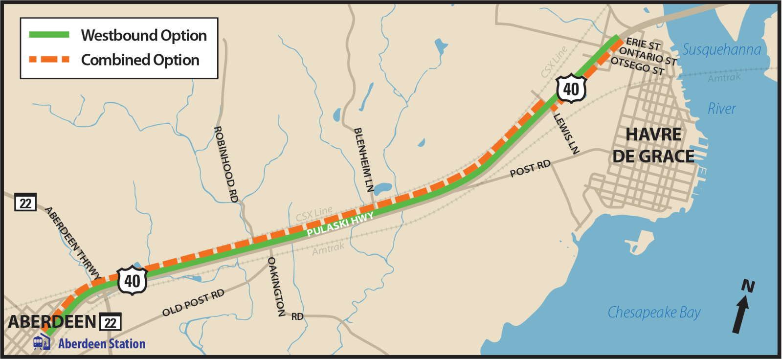
Concept Plan for Bicycle and Pedestrian Improvements along US 40 in Harford County
BMC partnered with Harford County to develop a concept plan for bicycle and pedestrian improvements along a 5-mile segment of US 40 in Harford County from the City of Aberdeen to the City of Havre de Grace. Three potential concept options were explored in the first phase with two options recommended for further study based on community feedback and design considerations. The proposed shared-use path for all options would be asphalt, 10 feet in width (8 foot minimum where necessary due to constraints) and include a grass buffer between the shared-use path and the closest edge of the roadway travel lane and would connect to transit and neighborhoods.
This concept plan will be used to develop future phases of design/construction and may be used to guide design standards for future development along the corridor.
Regional Active Transportation Count Program
BMC partners with member jurisdictions to perform weeklong bicycle, pedestrian and e-scooter counts throughout the Baltimore region. These counts help inform prioritization of active transportation improvements, track ‘before’ and ‘after’ volumes in locations with infrastructure improvements, assist with the selection of permanent count locations, contribute to safety assessments, and contribute to the statewide bicycle and pedestrian count database.
Transportation Alternatives Set-Aside Program
The Transportation Alternatives (TA) set-aside program is a federal aid funding program for transportation-related projects that strengthen the intermodal transportation system. Projects funded by the TA program can include pedestrian and bicycle facilities, recreational trails, safe routes to school projects, community improvements such as historic preservation and vegetation management, and environmental mitigation related to stormwater and habitat connectivity.
As the Metropolitan Planning Organization (MPO) for the Baltimore region, BRTB plays an important role in determining awards for TA grants. On behalf of BRTB, the BMC review team assesses each project in the Baltimore region through a competitive process grounded in the following criteria:
- Expected benefits to the community
- Feasibility and project readiness
- Sponsor’s demonstrated ability to manage a federal-aid project
- How the project advances the Goals and Strategies of Resilience 2050
- How the project improves public safety for all users
Recent projects funded by the TA program include the West East Express Trail in the City of Annapolis, Safe Routes to School improvements for Cecil Elementary School in Baltimore City, and improvements to the Patuxent Branch Trail in Howard County.
Communities can apply to both BRTB and the Maryland Department of Transportation (MDOT) at the same time though a joint application. More information about the application process can be found here.
Transportation and Land-Use Connections
The Transportation Land-Use Connections (TLC) competitive grant program provides short-term technical assistance to support local governments in their planning and preliminary design efforts to implement changes to the built environment that reduce traffic on roads and enable more people to easily walk, bike and use transit. Click here for more information about the program.
Recent projects include the Bay Ridge Avenue Bikeway Feasibility study and Bicycle Facility Standards for the City of Annapolis and the Wabash Avenue Multimodal Study in Baltimore City.

Pedestrian Infrastructure Assessment Toolkit
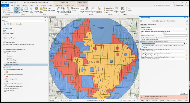
The Pedestrian Infrastructure Assessment Toolkit (PIAT) was developed by the Baltimore Regional Transportation Board in partnership with member jurisdictions. The PIAT includes three toolboxes designed to help member jurisdictions identify pedestrian infrastructure needs and prioritize potential pedestrian infrastructure projects.
The three toolboxes are:
- Data Management Toolbox –Create your own geodatabases structured to work with the PIAT, import your own layers and update existing layers.
- Needs Assessment Toolbox— Identify sidewalk and pedestrian crossing gaps, and evaluate pedestrian travelsheds. A travelshed is the area that can be traveled within a defined distance; 1) using continuous sidewalks and crosswalks, 2) by traveling in a straight-line or “as the crow flies” or 3) by using a user supplied network such as a street network.
- Prioritization Toolbox—Develop a ranked priority list of pedestrian infrastructure improvement locations. User can choose from a variety of demographic, transportation, and spatial variables and adjust their relative weights. The locations can be identified through the Needs Assessment Toolbox above, or through another process.
To use the PIAT, you will need:
- ArcGIS Pro—the Toolkit has been developed and tested in ArcGIS Pro 2.9.0.
- ArcGIS Pro Advanced license—needed for the Needs Assessment Toolbox to function fully. Basic and Standard license levels will work with limited functionality. See Section III.B in the manual for additional information.
- Spatial Analyst extension—needed for the Travelshed Analysis Tool.
- GIS experience related to data formatting.
- Sidewalk data—Can be acquired from OpenStreetMap.org or through the open data site for your city or county, if they have a publicly available sidewalk dataset. Note that this sidewalk data must be processed to be formatted as indicated in Appendix A of the Manual and imported according to instructions in Section II of the Manual.
Regional Bicycle Facilities Inventory
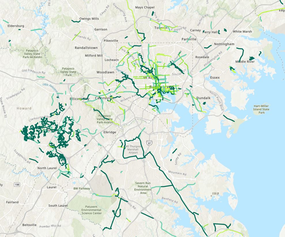
The regional bicycle facilities inventory originated with BPAG and the need to create a regional map of all current, programmed, and planned bicycle facilities to aid the planning process. The regional inventory is updated using bicycle facilities inventories maintained by each jurisdiction.
A map of the regional bicycle facilities inventory containing existing bicycle facilities can be viewed here. The raw ArcGIS data for the inventory can be downloaded via BMC’s Regional GIS Data Center.
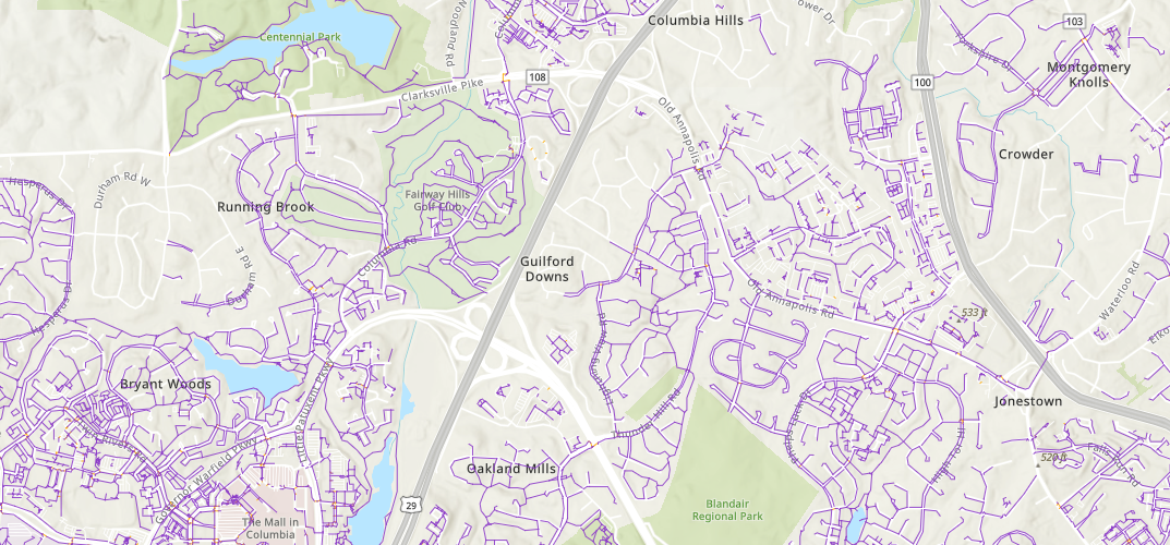
Baltimore Region Pedestrian Network
The Baltimore Region Pedestrian Network is a comprehensive sidewalk, crosswalk, curb ramp, and sidewalk buffer (planting strip) dataset. It was derived from 2001 imagery and was acquired by BMC to assist member jurisdictions with pedestrian planning in the region including identifying sidewalk and crosswalk gaps, prioritizing sidewalk projects, and other pedestrian planning efforts.
Cost Estimating Tool For Bicycle Infrastructure Projects
This planning level cost estimating tool has been developed by the Maryland Department of Transportation and the Baltimore Regional Transportation Board's Bicycle and Pedestrian Advisory Group. The purpose of this estimator is to provide guidance to local jurisdictions on project design and construction costs associated with bicycle infrastructure. Cost estimates within this tool are developed by identifying pay items and establishing generalized quantities, and a 30% contingency to allow for items not yet designed. The cost estimator is also provided as a general planning tool to compare costs from planning, development and engineering professionals. This tool was developed in December 2020 and will be updated annually.