On behalf of the Baltimore Regional Transportation Board (BRTB), thank you for your interest in our activities and efforts to update the region's long-range transportation plan - Maximize2045: A Performance-Based Transportation Plan. For many, the importance of the long-range transportation plan is the identification of major projects the region expects to implement over the next 20-25 years.
In late spring, the BRTB will release a draft Maximize2045, along with the 2020-2023 Transportation Improvement Program (TIP) and related air quality analysis, for public review. We share with you our steps along the way and invite you to get involved in the process by learning more about the steps and staying tuned for upcoming events and the public comment period.
How Projects are Evaluated
The BRTB approved a process for evaluating and scoring individual candidate projects for Maximize2045. This process is a tool the BRTB uses to compile a set of projects that will benefit the region based on its adopted goals and policies.
Aside from project scores and the need to maintain fiscal constraint, the BRTB considers other factors in establishing the list of projects for Maximize2045. These factors might include such considerations as how ready a project is to move forward in the project development process or how a project might address issues of particular local concern in a specific jurisdiction
A project’s total score consists of two parts:
- a policy score that is a combination of (a) how much of a priority (high, medium, or low) a project is to the submitting jurisdiction or agency and (b) whether or not the project has received financial support from MDOT
- a technical score based on criteria derived directly from the region’s adopted goals and policies.
The technical scoring criteria cover the following areas:
- Roadway safety (does a project include features to reduce injuries and fatalities?)
- Roadway accessibility (does a project incorporate Complete Streets features? does a project support access to an activity hub?)
- Transit accessibility (does a project improve an existing transit station/stop or provide a new transit station/stop?)
- Roadway mobility (will a project improve short- and long-term level of service?)
- Transit mobility (does a project provide additional transit options focused on moving riders reliably and efficiently? is a project expected to increase the average number of daily transit riders?)
- Environmental conservation (will a project avoid effects to ecologically significant lands or historic properties? does a project include features that reduce greenhouse gas emissions?)
- Security (does a project fall on an existing evacuation route or improve a critical link to an existing evacuation route?)
- Investment in priority areas (does a project lie within or connect to a Priority Funding Area or a designated Sustainable Community?)
This evaluation and scoring process supports the BRTB’s federally mandated responsibility to develop and carry out a continuing, cooperative, and comprehensive transportation planning process for the metropolitan area.
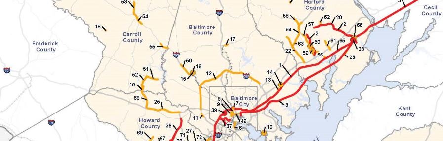
Submitted Projects
BRTB members have submitted a list of projects they’d like to have included in Maximize2045. Here are a few highlights:
- Freight related: Construct a full interchange at I-695 and Broening Highway
- Bridge Preservation: Replace the Howard Street Bridge over I-83, rail lines, Falls Road, and the Jones Falls
- Transit related: Add Bus Rapid Transit along U.S. 29 from Ellicott City / Downtown Columbia Transit Center to MD 198
Check out the full list of projects being evaluated
What's Next?
The next steps of the process to develop Maximize2045are:
- Project Evaluation Results – Project Evaluation Results - BMC staff have evaluated the submitted projects and completed the technical review. Based on the combined policy and technical scores, the BRTB selected the best scoring projects that could be implemented over the next 20-25 years given the amount of money available. Using modeling and analytical tools, BMC staff are now determining the potential effects of these projects on the region’s transportation network. These tools include (a) travel demand modeling, (b) air quality conformity modeling (in coordination with the Maryland Department of the Environment), (c) analyses to determine how the projects might benefit or burden Environmental Justice populations, and (d) consultations with resource agencies to identify issues related to potential effects on natural and cultural resources.
- Draft Plan Released for Public Comments – A draft of the plan will be made public for a comment period during May and June 2019 and we’ll hold a public meeting in each jurisdiction in the Baltimore region.
- Respond to comments and vote on a final plan – The BRTB will then review and respond to public comments and vote on a final plan in July 2019.